
![]()
![]()
![]()
![]()
![]()
![]()
![]()
![]()
![]()
Select Location to save TINs, and decide whether to put TINs into active View: If your elevation theme is a GRID, then this extension must generate a TIN surface to calculate surface and topographic characteristics of your features. If your elevation theme is a TIN and you are calculating surface data for polygons or circles around points, then this extension will create clipped TINs within the polygon boundaries (see Clipping TINs for a description of a clipped TIN). In either case you have the option to save the new TINs and add them to your view.
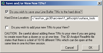
As this extension calculates TINs and surface area data for each
polygon, it has to save the TIN to the hard drive at least temporarily.
By default it will save it to your Current Working Directory, but
you can change this by typing in a new path name.
If you uncheck this option, the TIN will still be saved to the
Current Working Directory but it will then be deleted as soon as the
surface characteristics have been calculated.
This allows you to save hard drive space if you really don’t
want or need the TINs.
You also have the option to add your TINs to your View. If you want to do this, you must save the TINs to your hard drive. I’ve included a warning here that you might want to be careful about adding the TINs to your view if you’re creating more than a dozen or so at once. The author has had his ArcView session crash before when he's run scripts that add lots of TINs to his view. The 3D Analyst ReadMe file states that "There is a limit of 10-16 different TINs which can be open at the same time in one ArcView session. The number varies depending on whether the TIN directory contains TMSK, TNVAL, and TTVAL files. Do not try to open more than 10 different TINs in the same project. You can have more than 10-16 TIN object variables if some of them reference the same TIN source that's stored on disk."
Specify Hard Drive Location to save the RESULTS table: Regardless of whether you choose to join your RESULTS table with your polygon Feature Attribute Table, you will still be prompted to specify a location on the hard drive to save your RESULTS table. This is a standard ArcView Dialog Box and should be familiar to most users. This table is a permanent table and will not be deleted when ArcView is shut down.
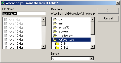
You may also see similar dialog boxes prompting you for a location to save your "High and Low Points" shapefile, if you have checked this option.
Enjoy! Please contact the author if you have problems or find bugs.
Jeff Jenness jeffj@jennessent.com
3020 N. Schevene Blvd.
Flagstaff, AZ 86004
USA
![]()
More Online Documentation for "Surface Tools for Points, Lines and Polygons" extension....
![]()
Please visit Jenness Enterprises ArcView Extensions site for more ArcView Extensions and other software by the author. We also offer customized ArcView-based GIS consultation services to help you meet your specific data analysis and application development needs.
![]()