
|
|
|
|
|
|
|
|
|
|
|
|
![]()
![]()

|
Last Modified: Revision 3.0.813, January 12, 2014 |
|
|
|
|
|
Downloads |
On-Line Manuals (requires Adobe Acrobat Reader) |
| Corridor Designer Evaluation Tools for ArcGIS 9.x (30.0 MB) | Manual in Letter (8.5 x 11) page size |
|
View and Download Full Corridor Designer Poster, Portrait View and Download Full Corridor Designer Poster, Landscape ---------------------------------- Featured in Fall 2010 Edition of ArcNews ---------------------------------- Download Corridor Designer Evaluation Tools Raw Code Files (Visual Basic 6 project file, 37.6 MB) |
|
|
Note: This ArcGIS extension is part of a larger suite of tools designed to assist with corridor design and analysis. For additional tools, plus tutorials, literature, blogs and sample datasets, please visit the Corridor Designer website at http://www.corridordesign.org. Do you know of any stable 50-year-old landscapes with patches and long, wide corridors, anywhere in the world? Please visit http://www.docorridorswork.org/ to review and possibly assist with a Northern Arizona University project evaluating how well conservation corridors work. |
|
Author: Jeff Jenness
Wildlife Biologist, GIS Analyst
Jenness Enterprises
3020 N. Schevene Blvd.
Flagstaff, AZ, 86004 USA
(928) 607-4638
CorridorDesigner (see http://www.corridordesign.org) includes ArcGIS procedures that allow you to develop a linkage design that best support movement by multiple focal species. In 2010, CorridorDesigner added new procedures that allow you to develop corridors that provide for continuity of land facets (recurring units of relatively uniform topography and soils); these are intended to provide a linkage that will provide wildlife connectivity during and after climate change. The ArcGIS portion of these Land Facet tools is available on both the Corridor Designer page and at http://www.jennessent.com/arcgis/land_facets.htm. In both cases, the procedures produce a design that represents “the best we can do” from an ecological perspective.
Here we offer a new set of tools, called Corridor Evaluation Tools, that allow you to describe various traits of one or more corridor polygons. Corridor evaluation tools are needed for two reasons.
| First “the best we can do” might not be very good. Least-cost modeling procedures always produce least-cost corridors – that is, lands that provide lower resistance to animal movement (or better continuity or interspersion of land facets) than any alternative. However, these corridors may still be pretty lousy. Analysts need to provide good honest assessments of how well the linkage design serves each focal species or land facet. | |
| Second, the linkage design ignores feasibility. County planners, city planners, and conservation investors aften want to consider alternatives that minimize dollar expenditures or that provide opportunities for other economic activities. For instance, the linkage design may include many small parcels (which have high transaction costs) or landowners who do not want to sell conservation easements. At the same time, there may be an opportunity to conserve an alternative swath of land that does not have these problems. Planners and investors need to know: How does this alternative compare to the optimal linkage design? Is it almost as good, half as good, or markedly inferior? |
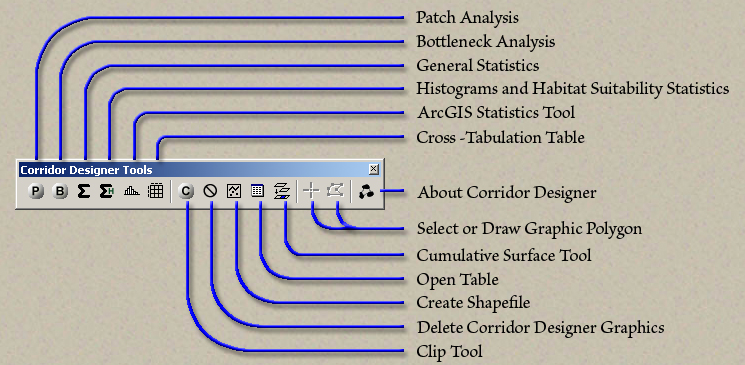
The Corridor Evaluation Tools allow developers, conservation groups, and planning agencies to create an alternative corridor by simply drawing it on the screen, selecting parcels of interest, or pointing to any polygon. They can then describe both the optimum corridor and any alternative corridor(s) to the optimum design in several ways:
| A list of the longest distances between consecutive patches of breeding habitat in each corridor polygon for each focal species | |
| Graphs depicting narrowness and length of bottlenecks in each corridor | |
| Frequency distributions of habitat quality for each focal species in each corridor | |
| Descriptive statistics for any raster or vector attribute of a corridor. | |
| Cross-tabulations of any two raster or vector attributes of a corridor. For example, a decision-maker may want a cross-tabulation of parcels based on parcel size and distance to paved road. If a polygon has many small parcels close to roads, that corridor would be much more difficult and expensive to protect than a corridor polygon consisting of large parcels far from paved roads. | |
| Circuit-theory metrics that characterize total resistance across all possible cells within each corridor (McRae. 2006. Evolution 60:1551–1561). |
With these descriptors, decision-makers can compare and make choices among alternative corridor designs. You may wonder why Corridor Designer doesn’t develop a linkage design that recognizes costs and other constraints from the outset, rather than proposing an ecologically optimum design and then considering more practical alternatives. The answer is that the optimum design is a crucially important baseline (the best we can possibly do) that allows decision makers to evaluate the ecological cost of a particular compromise.
Recommended Citation Format: For those who wish to cite this extension, the author recommends something similar to:
Jenness, J., D. Majka and P. Beier. Corridor Designer Evaluation Tools: Extension for ArcGIS. Jenness Enterprises. Available at: http://www.jennessent.com/arcgis/corridor.htm
Current Citation List (from Google Scholar):
| Corridor Designer | |
| Conceptual Steps for Designing Wildlife Corridors |
Requires: ArcGIS 9.1 or better (at any license level) or ArcGIS 10.
![]()
For detailed instructions on installation and
operation, view the on-line PDF version of
Corridor
Designer Evaluation Tools Manual
![]()
![]()
Revisions
Version 1.0
Build 1.4.762 (November 27, 2007)
| |||||
| |||||
Build 1.4.766 (December 12, 2007)
| |||||
Build 1.4.769 (December 12, 2007)
|
Version 2.0
Build 2.1.627 (October 4, 2009)
| |||||||||
Build 2.1.632 (March 15, 2010)
| |||||||||
Build 2.1.637 (October 29, 2010)
| |||||||||
Build 2.1.638 (November 10, 2010)
| |||||||||
Version 2.1.639: (November 16, 2010)
| |||||||||
Version 2.1.640: June 28, 2011
|
Version 3.0
Build 3.0.817 (January 12, 2014)
|
![]()
Enjoy! Please contact the author if you have problems or find bugs.
Jeff Jenness jeffj@jennessent.com
Jenness Enterprises http://www.jennessent.com
3020 N. Schevene Blvd.
Flagstaff, AZ 86004
USA
![]()
Please visit Jenness Enterprises ArcGIS Tools site for more ArcGIS tools and other software by the author. We also offer GIS consultation services for both ArcGIS and ArcView 3.x to help you meet your specific data analysis and application development needs.
![]()