
![]()
![]()
![]()
![]()
![]()
![]()
![]()

TABLE OF CONTENTS:
|
|
|||||
|
|
|||||
|
|
|
||||
|
|
|||||
|
|
|||||
|
|
![]()
I compared the output of the Surface Area and Surface Ratio grids derived by this extension with surface areas and ratios derived from a TIN-based analysis using the ESRI's 3D Analyst extension (ESRI 2000) and the author's Surface Tools extension (Jenness 2001). I computed the surface areas and ratios within 650 circular polygons ranging in size from 100m radius (approximately 3 grid cells) to 20,000m radius (approximately 146,454 grid cells). I used two methods of determining grid statistics within polygons (the "Standard" method and the "Modified" method) because I felt the standard method was giving me inaccurate results (see "Problems with 'ZonalStatsTable' Request" for details)..
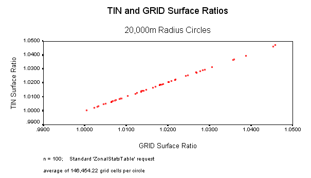
Surface Ratios: I found that Surface Ratios correlated very well at all scales and regardless of the method of determining grid statistics. The lowest correlation between Surface Ratio values was 0.981 (circle radius = 100, Standard Method). GRID-based values tended to be very close to TIN-based values, never differing more than 4% from their corresponding TIN-based value and rarely differing more than 1%. In almost all cases, both accuracy and precision increased as the size of the circle increased, so that the circles with the greatest numbers of grid cells tended to be the most accurate and precise.
Surface Areas; Standard Method: The Standard method of calculating statistics for surface areas tended to be variable and unreliable at cell counts <= 234 (circle radius = 800m). Correlations, accuracy and precision increased at higher cell counts except for the case of the 2,000m circles (mean cell count = 1,472), in which the Standard Method appeared to be considering too many cells in some of the circles. I suspect that the problem with the 2,000m circles had more to do with an apparent bug in the Standard Method than it did with the surface area grids, because correlations, precision and accuracy for the 2,000m circles greatly increased when I disregarded the 19 problematic circles.
Surface Areas; Modified Method: The Modified method of calculating statistics tended to produce much more precise results than the Standard method, with correlations ranging from 0.993 to 1.000. GRID-based values tended to be higher than their TIN-based counterparts at low cell counts (< 264), but accuracy greatly increased at cell counts higher than 234 (circle radius = 800m). For polygons with >= 264 cells, GRID-based values were almost identical to TIN-based values and both accuracy and precision were nearly perfect.
![]()
I tested the output accuracy of this extension by generating surface areas and ratios for 650 circular polygons in 7 different sizes and comparing results between a TIN-based method and the GRID-based method used by this extension. These 650 polygons were randomly distributed across an elevation grid and all the polygons were completely within the elevation grid boundaries (i.e. none of the polygons overlaid any "No Data" areas). For a control group, I used the Surface Tools extension (Jenness 2001) to calculate what I assume to be the most accurate Surface Area and Surface Ratio values possible from the elevation data. I used a Z-factor = 0 (meaning that the new TIN will go through all the elevation points and therefore be as complex as possible. See Surface Tools manual for an explanation).
I then generated surface areas and ratios using the Surface Area and Surface Ratio grids produced by this extension. I compared the GRID-based surface areas with the TIN-based surface areas for each of the 650 circular polygons using scatterplots, correlation statistics, and descriptive statistics. I used SPSS 9.0 to generate the statistics.
I used both a standard method and a modified method to generate grid cell statistics for the 650 circular polygons because I was uncertain that the standard method was producing accurate results (see "Problems with 'ZonalStatsTable' Request" for details). Results from both methods are presented here.
Standard Method: I used Spatial Analyst's "Summarize Zones..." menu item to generate total surface areas and mean surface ratios for the 650 sample circular polygons. For purposes of this comparison, this "Summarize Zones" operation treated each polygon as a separate "zone", then generated grid statistics for all those grid cells that lay within each zone.
Modified Method: Conceptually, this modified process can be pictured as taking each polygon separately, using it like a cookie cutter to clip out only those grid cells that lie within the polygon, then running 'ZonalStatsTable' on only that polygon and only those clipped grid cells. Technically, the modified version takes each polygon in the theme and converts it into a grid with the same cell size as the Input Grid, producing a grid of "1" values in the shape of the polygon. It then multiplies that grid by the Input Grid, thereby converting all cells outside of the polygon into "No Data" cells while retaining the original cell values inside the polygon. Finally, this extension uses the 'ZonalStatsTable' request on the modified input grid to generate statistics for that single polygon. This process eliminates the possibility that the 'ZonalStatsTable' request will select cells outside of the polygon boundary by converting all cells outside of the polygon boundary into "No Data" values.
Polygon radii are in meters and grids had a cell size of approximately 92.6 meters. The modified process causes the circular polygons to have identical numbers of cells for each radius size while the standard process can have variable cell counts in each radius size. The means, standard deviations and ranges reflect the ratios of (GRID Surface Area) divided by (TIN Surface Area), or the ratio of (GRID Surface Ratio) divided by (TIN Surface Ratio).
![]()
Surface Area/Ratio Comparison using Standard Method:
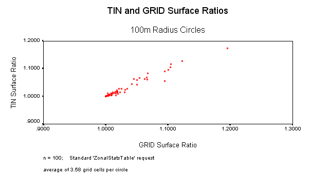
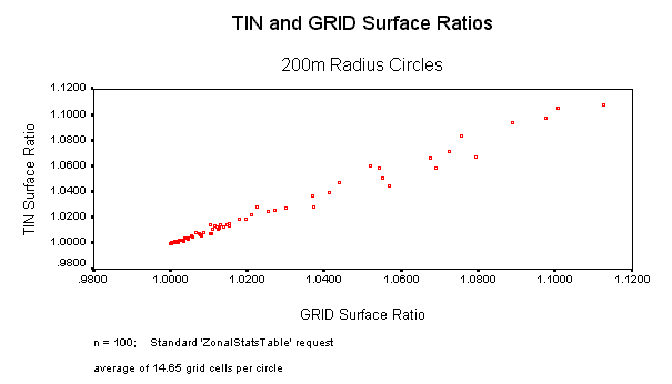
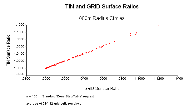
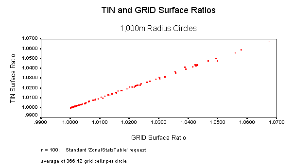
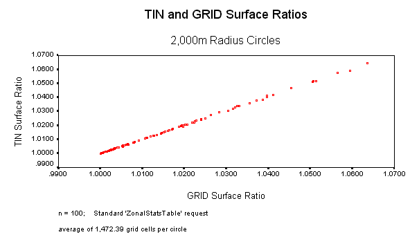
In all cases, Surface Ratio values using the Standard method were very close between the TIN-based and GRID-based calculations. Accuracy and precision increased with higher cell counts, but even in the worst case the GRID-based calculation was only 4% different than the TIN-based calculation.
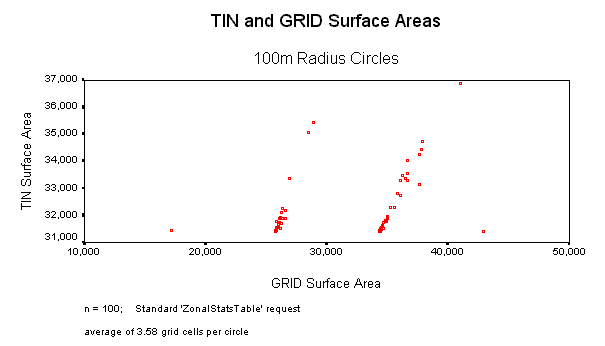
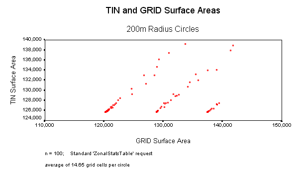
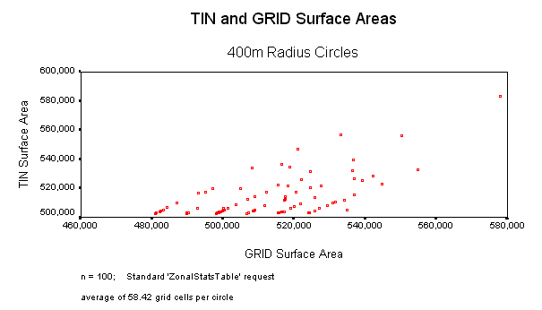
At low cell counts, this Standard method produced highly variable results with low correlations between TIN-based and GRID-based surface areas. Circular polygons can have variable cell counts depending on their placement on the grid and these different cell counts can have significant effects on the internal areas. The scatterplot for the 100m circles comparing Surface Areas clearly shows 4 groupings of points, and the groups are explained by the cell counts. There are very distinct separations between those circles with 2, 3, 4 or 5 cells. These distinct groupings are still visible in the 200m and 400m circles, but they start to blend together at higher cell counts.
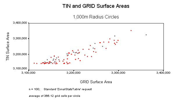
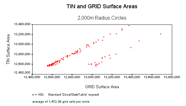
At high cell counts this Standard method generally produced very accurate and precise surface areas, with the exception of the 2,000m circles. Something strange happened there, and surface areas for 19 of these circles apparently included grid cells that were outside the circle. The scatterplot for the 2,000m surface areas shows two distinct groupings of points and I suspect that one of these groups was somehow calculated incorrectly. This problem with the 2,000m points led me to develop the Modified method of generating statistics.
SURFACE AREAS: TIN vs. GRID-based Output using Standard ZonalStatsTable Request |
||||||
|
Circle Radius |
n |
Avg. # Grid Cells in Polygon | Surface Area Comparison | |||
| Pearson Correlation | (GRID Surface Area) / (TIN Surface Area) | |||||
| mean | sd | range | ||||
| 100 | 100 | 3.58 | 0.323 | 0.9793 | 0.1469 | 0.54 - 1.37 |
| 200 | 100 | 14.65 | 0.400 | 1.0013 | 0.0498 | 0.94 - 1.10 |
| 400 | 100 | 58.42 | 0.675 | .09978 | 0.0261 | 0.95 - 1.06 |
| 800 | 100 | 234.32 | 0.969 | 1.0005 | 0.0065 | 0.99 - 1.03 |
| 1,000 | 100 | 366.12 | 0.914 | 1.0006 | 0.0069 | 0.99 - 1.02 |
| 2,000 | 100 | 1,472.39 | 0.733 | 1.0059 | 0.0133 | 1.00 - 1.04 |
| 2,000* | 81 | 1,463.12 | 0.996 | 0.9995 | 0.0014 | 1.00 - 1.00 |
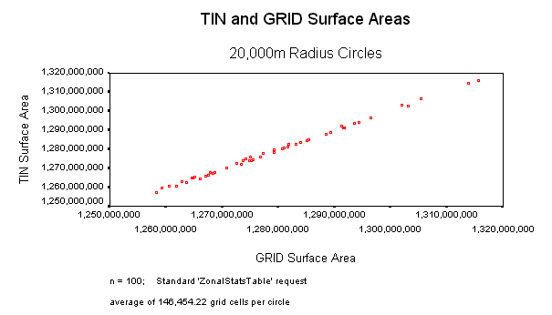
| 20,000 | 50 | 146,454.22 | 0.999 | 1.0002 | 0.0006 | 1.00 - 1.00 |
|
* Disregarding 19 apparently incorrect surface area values |
||||||
SURFACE RATIOS: TIN vs. GRID-based Output using Standard ZonalStatsTable Request |
||||||
|
Circle Radius |
n |
Avg. # Grid Cells in Polygon | Surface Ratio Comparison | |||
| Pearson Correlation | (GRID Surface Ratio) / (TIN Surface Ratio) | |||||
| mean | sd | range | ||||
| 100 | 100 | 3.58 | 0.981 | 1.0007 | 0.0060 | 0.98 - 1.04 |
| 200 | 100 | 14.65 | 0.994 | 1.0002 | 0.0027 | 0.99 - 1.01 |
| 400 | 100 | 58.42 | 0.998 | 0.9999 | 0.0015 | 0.99 - 1.01 |
| 800 | 100 | 234.32 | 1.000 | 0.9997 | 0.0008 | 1.00 - 1.00 |
| 1,000 | 100 | 366.12 | 1.000 | 0.9999 | 0.0005 | 1.00 - 1.00 |
| 2,000 | 100 | 1,472.39 | 1.000 | 0.9998 | 0.0004 | 1.00 - 1.00 |
| 2,000* | 81 | 1,463.12 | 1.000 | 0.9997 | 0.0004 | 1.00 - 1.00 |
| 20,000 | 50 | 146,454.22 | 1.000 | 0.9995 | 0.0004 | 1.00 - 1.00 |
|
* Disregarding 19 apparently incorrect surface ratio values |
||||||
|
TIN vs. GRID Comparison
Scatterplots, using Standard ZonalStatsTable Request |
||
| Circle Data | Surface Area Scatterplots | Surface Ratio Scatterplots |
| radius = 100 3.58 cells n = 100 |
 |
 |
| radius = 200 14.65 cells n = 100 |
 |
 |
| radius = 400 58.42 cells n = 100 |
 |
 |
| radius = 800 234.32 cells n = 100 |
 |
 |
| radius = 1,000 366.12 cells n = 100 |
 |
 |
| radius = 2,000 1,472.39 cells n = 100 |
 |
 |
| radius = 20,000 146,454.22 cells n = 50 |
 |
 |
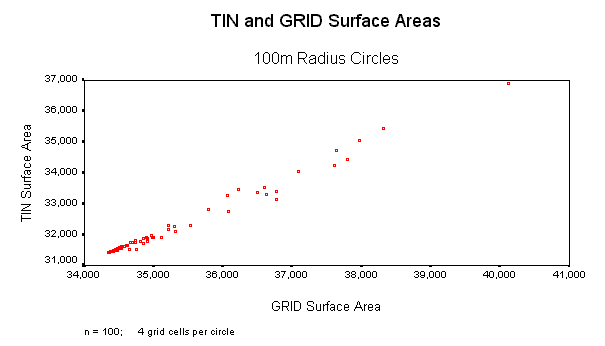
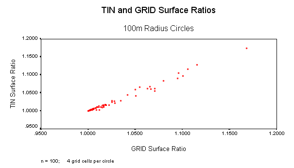
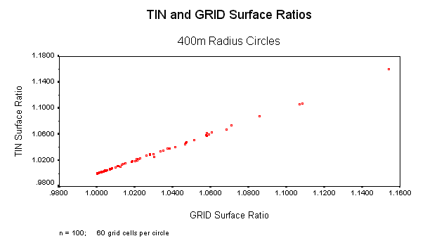
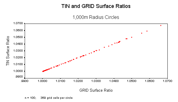
Surface Area/Ratio Comparison using Modified Method:
In all cases, Surface Ratio values using the Modified method were very close between the TIN-based and GRID-based calculations. Accuracy and precision increased with higher cell counts, but even in the worst case the GRID-based calculation was only 1% different than the TIN-based calculation.
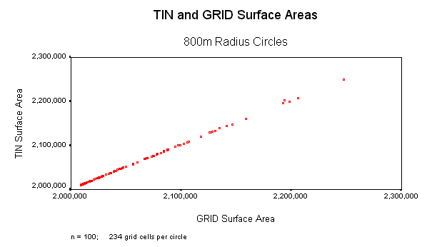
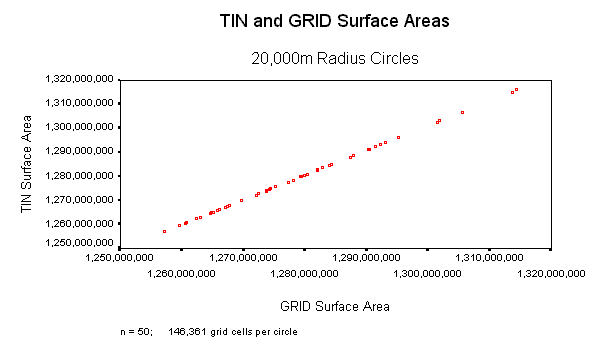
Surface Area values were always highly correlated, but GRID-based calculations tended to be higher than TIN-based calculations at low cell counts. Surface area values for the 100m circles, with 4 grid cells each, tended to be over 9% higher when calculated from the Grids. GRID-based surface areas for circles with up to 60 cells tended to be about 2.5% higher than their corresponding TIN-based surface areas.
Surface areas for circles with cell counts >= 234 tended to be almost identical between the GRID- and TIN-based calculations, and correlations were almost perfect.
SURFACE AREAS: TIN vs. GRID-based Output using Modified ZonalStatsTable Request |
||||||
|
Circle Radius |
n |
Avg. # Grid Cells in Polygon | Surface Area Comparison | |||
| Pearson Correlation | (GRID Surface Area) / (TIN Surface Area) | |||||
| mean | sd | range | ||||
| 100 | 100 | 4 | 0.993 | 1.0937 | 0.0039 | 1.08 - 1.11 |
| 200 | 100 | 15 | 0.996 | 1.0252 | 0.0022 | 1.02 - 1.04 |
| 400 | 100 | 60 | 0.999 | 1.0249 | 0.0011 | 1.02 - 1.03 |
| 800 | 100 | 234 | 1.000 | 0.9991 | 0.0004 | 1.00 - 1.00 |
| 1,000 | 100 | 369 | 1.000 | 1.0084 | 0.0003 | 1.01 - 1.01 |
| 2,000 | 100 | 1,465 | 1.000 | 1.0008 | 0.0003 | 1.00 - 1.00 |
| 20,000 | 50 | 146,361 | 1.000 | 0.9996 | 0.0003 | 1.00 - 1.00 |
SURFACE RATIOS: TIN vs. GRID-based Output using Modified ZonalStatsTable Request |
||||||
|
Circle Radius |
n |
Avg. # Grid Cells in Polygon | Surface Ratio Comparison | |||
| Pearson Correlation | (GRID Surface Ratio) / (TIN Surface Ratio) | |||||
| mean | sd | range | ||||
| 100 | 100 | 4 | 0.993 | 1.0004 | 0.0036 | 0.99 - 1.01 |
| 200 | 100 | 15 | 0.996 | 1.0002 | 0.0021 | 1.00 - 1.01 |
| 400 | 100 | 60 | 0.999 | 0.9999 | 0.0011 | 0.99 - 1.00 |
| 800 | 100 | 234 | 1.000 | 0.9998 | 0.0004 | 1.00 - 1.00 |
| 1,000 | 100 | 369 | 1.000 | 0.9998 | 0.0003 | 1.00 - 1.00 |
| 2,000 | 100 | 1,465 | 1.000 | 0.9998 | 0.0003 | 1.00 - 1.00 |
| 20,000 | 50 | 146,361 | 1.000 | 0.9995 | 0.0002 | 1.00 - 1.00 |
|
TIN vs. GRID Comparison
Scatterplots, using Modified ZonalStatsTable Request |
||
| Circle Data | Surface Area Scatterplots | Surface Ratio Scatterplots |
| radius = 100 4 cells n = 100 |
 |
 |
| radius = 200 15 cells n = 100 |
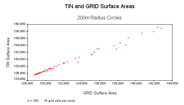 |
 |
| radius = 400 60 cells n = 100 |
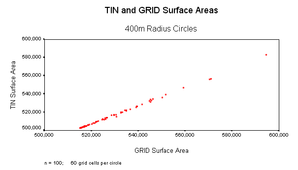 |
 |
| radius = 800 234 cells n = 100 |
 |
 |
| radius = 1,000 369 cells n = 100 |
 |
 |
| radius = 2,000 1,465 cells n = 100 |
 |
 |
| radius = 20,000 146,361 cells n = 50 |
 |
 |
![]()
This extension appears to generate accurate surface area and surface ratio grids. A cell value in a surface area grid appears to accurately reflect the surface area within that cell's boundaries.
Surface areas within polygons can be accurately measured with this method provided the polygon contains a sufficient number of cells. With the circular polygons used in this analysis, accuracy and precision tended to be very high when cell counts equaled or exceeded 264. However, accuracy decreased significantly when using the Standard method on 2,000m circles (mean cell count = 1,472.39), and I suspect this lack of accuracy was due to a bug in the internal ArcView ZonalStatsTable request. There was clearly something wrong with the calculation method in the case of the 2,000m circles, and therefore I cannot be certain that the problem does not also exist in other cases.
Surface areas using the Modified method appeared to be consistently precise, accurate and reliable for cell counts >= 264.
Accuracy in cases of low cell counts is highly variable when using the Standard method, although most of this variation is likely due to the fact that identically-sized circles randomly placed on a grid will not generally have the same number of cells in each circle. A cell is considered to be included in a circle if that cell's center is located within the circle boundary, and slight deviations in position can cause large numbers of cells to be included or excluded. Accuracy is consistently low in cases of low cell counts when using the Modified method, with GRID-based values tending to be significantly higher than TIN-based values.
![]()
I feel that this extension does produce reliable surface area and surface ratio values when the area of interest includes a large number of cells (>= 264). I leave it to the user to decide whether the Standard or Modified method of generating statistics is preferable. This extension offers the choice to generate statistics using either method. The Standard method is much faster, but did produce some mysterious results in this data set. The modified method appears to consistently overestimate the surface area at low cell counts, but appears highly accurate at high cell counts.
![]()
ESRI. 3D Analyst - ArcView Extension. Review available at http://www.esri.com/software/arcview/extensions/3dext.html.
Jenness, Jeff S. 2001. Surface Tools for Points, Lines and Polygons v. 1.3 - ArcView Extension. Jenness Enterprises. Available for review and download at http://www.jennessent.com/arcview/surface_tools.htm.
SPSS, Inc. 1998. SPSS For Windows. Version 9.0. 444 North Michigan Avenue, Chicago, IL, USA, 60611.
![]()
Enjoy! Please contact the author if you have problems or find bugs.
Jeff Jenness jeffj@jennessent.com
3020 N. Schevene Blvd.
Flagstaff, AZ 86004
USA ![]()
More Online Documentation for " Surface Areas and Ratios from Elevation Grid" extension....
![]()
Please visit Jenness Enterprises ArcView Extensions site for more ArcView Extensions and other software by the author. We also offer customized ArcView-based GIS consultation services to help you meet your specific data analysis and application development needs.
![]()