
NAME: Dissolve
Adjacent Polygons, v. 1.8a (Click Name to Download)
Aka: diss_adjac.avx
Last modified:
March 22, 2006
TOPICS: ArcView 3.x,
polygon, dissolve, merge, union, eliminate, adjacent, combine, sliver,
attribute
AUTHOR:
Jeff Jenness
Wildlife Biologist, GIS
Analyst
Jenness Enterprises
3020 N. Schevene Blvd.
Flagstaff,
AZ 86004
(928) 607-4638
jeffj@jennessent.com
DESCRIPTION: This
extension enables the user to eliminate small polygons by combining them
with larger adjacent polygons. You begin by specifying a size
limit and the extension will eliminate all polygons smaller than this
limit. The extension creates a new shapefile of combined polygons
so your original polygon theme is not altered. All attributes of
the larger polygon will be saved.
This function is especially useful for eliminating
small sliver polygons that may be created during digitizing, and is also
useful for projects that require a set of polygons that are all greater
than a particular size.
All or only selected records: You can
either analyze all the polygons in the polygon theme to see if they
should be dissolved or only a selected subset of polygons.
Option to use attribute values: You can
choose which adjacent polygon to dissolve in to based purely on the size
of the polygon, or you can dissolve only into polygons with identical
attribute values.
Combine with either largest or smallest adjacent
polygon, or with polygon with longest adjacent border: You may
specify which larger polygon you want your small polygons to be combined
with based on the size or border length of the adjacent polygons. If two
small polygons combine, and the new polygon is larger than your
specified limit, then that new polygon will not be combined into any
larger adjacent polygons.
Two options for "Adjacent": This
extension allows you to define "adjacent" as meaning that the two
polygons share either a common border or a common point. If you imagine
a chess board, two same-colored squares that touch each other diagonally
are adjacent at a single point. This extension gives you the option to
decide whether that type of adjacency is good enough for your purposes,
or if you need the two polygons to share a common boundary.
Report of polygon actions: After the
extension finishes, you will get a report of all the small polygons that
were eliminated and which larger polygon they were combined with. This
report is saved to the hard drive as a text file.
Requires: This extension requires at
least a single polygon theme present in a view. It will ask for a field
with unique values for each feature, but such a field is not necessary.
This extension also requires that the file
"avdlog.dll" be present in the ArcView/BIN32 directory (or
$AVBIN/avdlog.dll) and that the Dialog Designer extension be located in
your ArcView/ext32 directory, which they usually are if you're running
AV 3.1 or better. The Dialog Designer doesn't have to be loaded; it just
has to be available. If you are running AV 3.0a, you can download the
appropriate files for free from ESRI at:
http://support.esri.com/index.cfm?fa=downloads.patchesServicePacks.viewPatch&PID=25&MetaID=483
Recommended Citation Format: For those who wish
to cite this extension, the author recommends something similar to:
Jenness, J. 2006. Dissolve adjacent polygons
(diss_adjac.avx) extension for ArcView 3.x, v. 1.8a. Jenness Enterprises.
Available at:
http://www.jennessent.com/arcview/dissolve_adjacent_polys.htm.
Please let me know if you cite this extension in a
publication (jeffj@jennessent.com).
I will update the citation list to include any publications that I am
told about.
Updates: Version 1.4 (Oct. 7, 2003) changes
some of the algorithms to make it run faster, and changes the method of
identifying adjacent polygons so that it doesn’t occasionally miss
polygons that lie completely within another polygon. Also several
cosmetic changes
Version 1.5 (Dec. 11, 2003) fixes a bug that caused
the extension to hang if it encountered multiple null polygons. Also
gives the user the option to only consider a selected subset of polygons
to dissolve.
Version 1.51 (Jan. 29, 2004) corrects a bug in which
it was incorrectly identifying adjacent polygons that only touched at a
single vertex.
Version 1.52 (February 28, 2004) adds the option to
combine small polygons with adjacent polygon having the longest common
border.
Version 1.7 (February 7, 2005) adds the option to
dissolve based on common attribute values, plus adds a Table menu item to
add record numbers to the table.
Version 1.8 (March 10, 2006) corrects a bug that could
occur if the ID field contained a long alias, as well as adds a function
for searching for errors in the scripts.
Version 1.8a (March 22, 2006) corrects a bug caused by
the last revision. Sorry about that!

General Instructions:
1) Begin by placing the "diss_adjac.avx"
file into the ArcView extensions directory
(../../Av_gis30/Arcview/ext32/).
2) After starting ArcView,
load the extension by
clicking on File à Extensions…
, scrolling down through the list of available extensions, and then
clicking on the checkbox next to the extension called "Dissolve
Adjacent Polygons"
3) From a View, select
the  icon from
the View.
icon from
the View.
4) You will now see the "Select
Polygon Theme and Dissolve Options" dialog box:
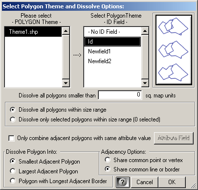
Polygon Theme and ID Field:
Begin by selecting the polygon theme and an ID Field that uniquely
identifies the polygons. This ID field is only used for generating
the report, so it's not necessary for the calculations. If you
don't have an ID field and you don't feel like making one, you can
select "- No ID Field -" and the extension will run just fine.
Size Limit: Next specify the
size limit for small polygons. All polygons smaller than this
limit will be dissolved into larger adjacent polygons. If you have
a polygon that is smaller than the limit, but is not touching any other
polygons, then it can't be dissolved. You will be alerted to that
circumstance at the end of the script's operation, and there will also
be a note in the report.
Choose All Polygons or Selected
Polygons: If you have a very large number of polygons to
dissolve, you may find it helpful to pre-select different regions of the
theme or perhaps different size ranges of polygon to work with. If
you choose to dissolve only selected polygons, then the tool will only
consider dissolving those small polygons that are already selected. This
will NOT affect which adjacent polygon a small polygon may be dissolved
into. They may still be dissolved into non-selected polygons, but no
non-selected polygon will be analyzed with this option.
Only dissolve polygons with same
attribute value: This option will only dissolve polygons into
other polygons if they have the same attribute value. If you choose this
option, you will need to select the attribute field before you can click
the 'OK' button. After you select the attribute field, the field name
will appear on the button to indicate that the attribute field has been
chosen.
Size Option: Next decide
whether you want the small polygons to be dissolved into the smallest or
largest adjacent polygons, or the polygon with the longest common
border. If two small polygons are combined early in the process, and the
combined polygon is larger than the specified size limit, then that new
polygon will not be dissolved into any adjacent polygons.
Adjacency Option: Finally,
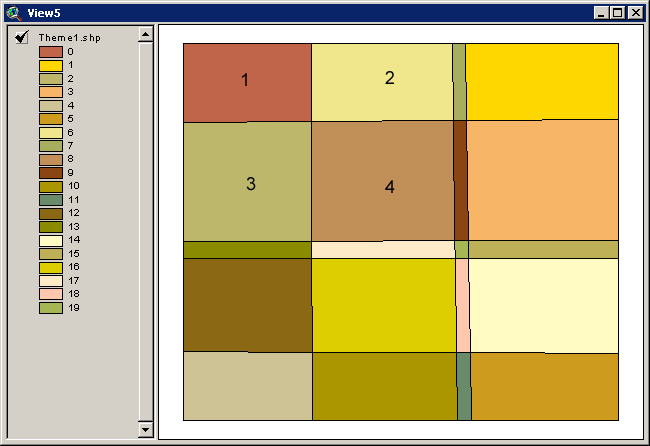
decide what rule of "adjacent" you want to use. In the
following illustration, Polygon 1 touches three other polygons (Polygons
2, 3 and 4). However, it only touches Polygon 4 at a single
point. If you want to allow Polygon 1 to be combined with Polygon
4, then use the "Share common point or vertex" option.
If you want would rather that Polygon 1 be restricted such that it can
only be combined with Polygons 2 or 3, then use the "Share common
line or border" option.
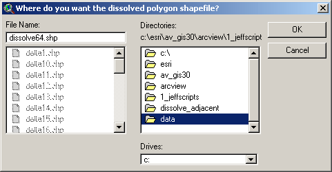
5) Specify hard drive location to save the
new shapefile: You will still be prompted to specify a
location on the hard drive to save the new shapefile of combined
polygons. This shapefile will also appear in your view. This is a standard ArcView
Dialog Box and should be familiar to most users. This shapefile is
permanent and will not be deleted when ArcView is shut down.
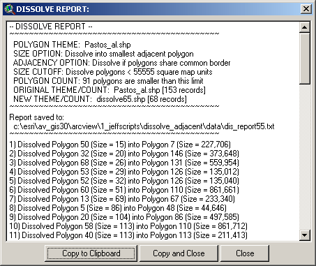
6) Report: After the
extension finishes, you will get a popup window with a report detailing
which polygons were combined and in what order. This report is
also saved to the hard drive at the location mentioned in the popup
window:
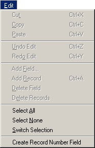
Adding Record Numbers to Table:
This option provides a simple way to add a
field of record numbers to your table. Many types of analysis require that
you have some kind of unique ID value in your attribute table, and record
numbers usually make good ID values when no other option exists. This
extension also asks for a field of unique ID values, although it is not
critical to the analysis and is only used to identify which specific
polygons were dissolved in the report.
All you need to do is open your table,
click the “Edit” menu, and then click “Create Record Number Field”. The
table does NOT need to be set to Editable prior to this. The tool will add
a field named [rec_num] and populate it with record number values. If a
field named [rec_num] already exists in your table, the tool will append
an index number to the name until it finds a name that does not exist in
your table (i.e. [rec_num_1], [rec_num_2], etc.)
Calculation Methods:
This extension begins by copying the
polygon shapefile into a new shapefile at the specified location and
adding two new fields to the new shapefile:
rec_num: The record
number of that polygon in the Feature Attribute Table.
This extension requires that each polygon be uniquely
identified, and the record number guarantees a unique
identity. This is different than the Unique ID field
specified by the user, which is only used in providing Polygon
ID values for the report.
dslv_area: The area
of the polygon. This field is used to identify those
polygons that are smaller than the specified area.
Using the area values from the dslv_area
field, the extension identifies all those polygons that are smaller
than the specified size. It then makes a list of those small
polygons and sorts the polygons by size, from the smallest to the
largest.
Beginning with the smallest polygon
(or the first polygon in the list), the extension selects all the
surrounding polygons that the small polygon touches. This
selection includes all those polygons that the small polygon touches
at only a single point.
If the user has selected the
"Share common line or border" option, the extension
then checks all the selected polygons and discards those that
only touch at a single point. This option also checks whether the smaller
polygon is enclosed by the larger.
If the user has specified an attribute field, then
the extension checks all the selected polygons and discards those
with different attribute values.
The extension then checks the size of all the remaining selected
polygons and identifies either the largest, smallest, or the one
with the longest common border, based on the user's choice.
After identifying the
largest/smallest polygon, the extension then performs the UNION
request to combine the two polygons. This generates a
brand new combined polygon that is completely separate from the
original small and large polygons. The extension then runs
the CLEAN request to ensure that the new polygon is a valid
polygon.
The extension then replaces the
original large polygon with the new combined polygon, such that
all the attribute values of the original large polygon now are
associated with the new combined polygon. The original
large polygon is now gone.
The extension then deletes the
smaller polygon from the shapefile entirely.
It's possible that the small
polygon will be an island somehow and have no other polygons
adjacent to it. If this is the case, the extension will
skip this polygon and insert a note in the report stating that
this polygon had no adjacent polygons and therefore could not be
combined with any. If this happens, you will be notified
of all such island polygons in an alert popup window after the
extension finishes running.
The extension then proceeds to the
next small polygon in the list. It's possible at this point
that the current small polygon has already been combined with an
even smaller polygon, and that the new size is larger than the
specified size limit. If this is the case, the extension will
skip this polygon and insert a comment in the report stating that
the polygon no longer needed to be combined with an adjacent large
polygon. Otherwise, the extension will repeat the process
described above.
The extension then repeats the entire
process for all the remaining small polygons in the small polygon
list.
After dissolving all the small
polygons in the shapefile, the extension then removes any null
polygons that may be present.
Troubleshooting:
Please
let the author know If the extension crashes for any reason. If it does
crash, and if ArcView is still running, click the menu item “Check
‘Dissolve Adjacent’ Scripts” in the View “Help” menu to generate a report
of all scripts that appear to be malfunctioning. Please copy this report
into an email or text file and email it to the author. This report will
help the author to identify and fix the problem.
Enjoy! Please contact the author if you have problems or find bugs.
Jeff Jenness
jeffj@jennessent.com
3020 N. Schevene Blvd.
Flagstaff, AZ 86004
USA
Please visit Jenness Enterprises ArcView
Extensions site for more ArcView Extensions and other software by
the author. We also offer customized ArcView-based GIS consultation
services to help you meet your specific data analysis and application
development needs.

