
|
|
|
|
|
|
|
|
|
|
|
|
![]()
![]()
|
*** Award Winning Software *** |
|
Last Modified: Revision 2.1.375, May 12, 2013 |
|
|
|
|
|
Downloads |
On-Line Manuals (requires Adobe Acrobat Reader) |
|
DEM Surface Tools
for ArcGIS 9.x (15.0
MB) DEM Surface Tools for ArcGIS 10 (16.2 MB) |
Manual in Letter (8.5 x 11) page size |
|
View and Download DEM Surface Tools Poster View and Download Surface Areas and Ratios Poster |
|
Topics: Sphere, geodesic, great circle, surface, area, ratio, elevation, topography, roughness, convolution, convolutedness, rugosity, terrain, geomorphology, slope, aspect, curvature, MDOW, hillshade
Author: Jeff Jenness
Wildlife Biologist, GIS Analyst
Jenness Enterprises
3020 N. Schevene Blvd.
Flagstaff, AZ, 86004 USA
(928) 607-4638
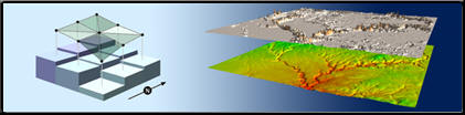
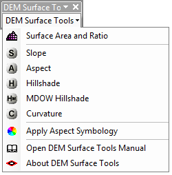
Description: This extension provides you with tools to generate a variety of surface characteristics of a landscape, using both projected and unprojected (i.e. latitude / longitude) digital elevation model (DEM) rasters. These tools include:
- Surface Area and Ratio of a landscape
- Slope, with 3 slope algorithm options
- Aspect, with 3 aspect algorithm options, and an additional tool to apply a traditional directional Aspect symbology to an existing Aspect raster.
- Hillshade, with optional hypsometric tinting
- Multi-directional Oblique-Weighted Hillshade, with optional hypsometric tinting
- Seven types of Landscape Curvature
ArcGIS has many useful tools for calculating slope, aspect, hillshade and curvature from DEM rasters. This extension offers some advantages over these existing tools in that:
| These tools correctly handle Latitude / Longitude Data: The existing ArcGIS tools typically do not work well with data in a geographic coordinate system (i.e. Latitude / Longitude coordinates). They expect the vertical units of a digital elevation model to be the same as the horizontal units, and at best they only allow you to enter in an adjustment factor (generally called a "Z-factor") to adjust your Z-units to your X/Y-units. This Z-factor adjustment method is cumbersome to implement with latitude/longitude coordinate systems because the correct Z-factor is both hard to calculate and changes with latitude. Geographic data is especially confounding because the X-units are not the same as the Y-units. Both are in "degrees", but a degree in latitude (Y-units) is not the same distance as a degree in longitude (X-units). |
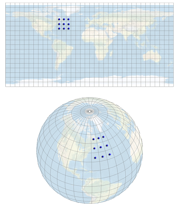
Unfortunately, most free elevation data available online is only available in latitude/longitude coordinates. This data can be projected, but projecting raster data introduces errors in resolution and precision (see horizontal and vertical artifacts on illustration in manual). This extension modifies the algorithms used to calculate common morphological characteristics of the landscape so that they accurately work with latitude/longitude data without projecting the data or using Z-factor adjustments.
All methods are described in detail in the manual, but in general this extension will always automatically detect the coordinate system of the raster and use the method appropriate for that coordinate system.
| These tools offer several options not available in
the standard ArcGIS tools: Including multiple slope and aspect
algorithms, optional hypsometric shading for hillshades, the MDOW model
for hillshades, and many more options for landscape curvature. | |
| Surface Area and Ratio: This extension allows
you to generate Surface Area and Surface Ratio rasters from an existing
Elevation raster. The cell values for these new rasters reflect the
surface area and (surface area) / (planimetric area) ratio for the land
area contained within that cell's boundaries. Both Surface Area and
Surface Ratio provide useful indices of topographic roughness and
convolutedness, and can give a more realistic estimate of the land area
available than you can get from the simple planimetric area. | |
| These tools do not require Spatial Analyst: This extension uses only standard ArcGIS ArcObjects functions and therefore does not require a license for either Spatial Analyst or 3D Analyst. |
Recommended Citation Format: For those who wish to cite this extension, the author recommends something similar to:
Jenness, J. 2013. DEM Surface Tools for ArcGIS (surface_area.exe). Jenness Enterprises. Available at: http://www.jennessent.com/arcgis/surface_area.htm.
Current Citation List (from Google Scholar):
| Surface Area Citations | |
| DEM Surface Tools Citations |
Requires: ArcGIS 9.2 or better, at any license level, or ArcGIS 10.
Important: This extension does not require Spatial Analyst or 3D Analyst. It will work just fine without any add-on extensions.
![]()
For detailed installation and operation instructions, view the on-line PDF version of
DEM
Surface Tools Manual
![]()
![]()
Revisions
Version 1.0
| Build 1.0.130 (July 7, 2009): Initial Release | |
| Build 1.0.131 (July 8, 2009): Fixed web site address in "About" dialog. | |
| Build 1.0.137 (April 8, 2010): Wrote a work-around for an ArcObjects bug in which the rasters would not be correctly written to the hard drive, even when they showed correctly in the map. | |
| Build 1.0.138 (May 27, 2010): Removed code that generated a series of message boxes during the analysis. |
Version 2.0
Build 2.0.230 (July 5, 2010):
| |||||||||||
Build 2.1.252 (October 10, 2010)
| |||||||||||
Build 2.1.254 (October 20, 2010)
| |||||||||||
Build 2.1.272 (November 16, 2010)
| |||||||||||
Build 2.1.292 (February 16, 2011)
| |||||||||||
Build 2.1.292 (February 13, 2011)
| |||||||||||
Build 2.1.298 (June 27, 2011)
| |||||||||||
Build 2.1.299 (July 15, 2011)
| |||||||||||
Build 2.1.305 (February 1, 2012)
| |||||||||||
Build 2.1.348 (January 19, 2013)
| |||||||||||
Build 2.1.375 (May 12, 2013)
|
![]()
Enjoy! Please contact the author if you have problems or find bugs.
Jeff Jenness jeffj@jennessent.com
Jenness Enterprises http://www.jennessent.com
3020 N. Schevene Blvd.
Flagstaff, AZ 86004
USA
![]()
Please visit Jenness Enterprises ArcGIS Tools site for more ArcGIS tools and other software by the author. We also offer GIS consultation services for both ArcGIS and ArcView 3.x to help you meet your specific data analysis and application development needs.
![]()