
|
|
|
|
|
|
|
|
|
|
|
|
![]()
![]()
|
Last Modified: Revision 1.5.152, November 4, 2012 |
|
|
|
|
|
Downloads |
On-Line Manuals (requires Adobe Acrobat Reader) |
|
Repeating Shapes for ArcGIS
9.x (9.3 MB) Repeating Shapes for ArcGIS 10.x (10.5 MB) |
Manual in Letter (8.5 x 11) page size |
|
View and Download Repeating Shapes Poster |
|
Topics: hexagon, square, rectangle, triangle, repeat, sample, tessellation, array, matrix, lattice, point, systematic, grid, extent
Author: Jeff Jenness
Wildlife Biologist, GIS Analyst
Jenness Enterprises
3020 N. Schevene Blvd.
Flagstaff, AZ, 86004 USA
(928) 607-4638
Description: Researchers and land managers often require a way to systematically divide the landscape into equal-sized portions. Breaking up the landscape this way simplifies monitoring plans, and is an essential step in developing systematic sampling designs.
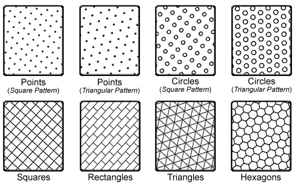
This tool generates an array of repeating shapes over a user-specified area. These shapes can be hexagons, squares, rectangles, triangles, circles or points, and they can be generated with any directional orientation.
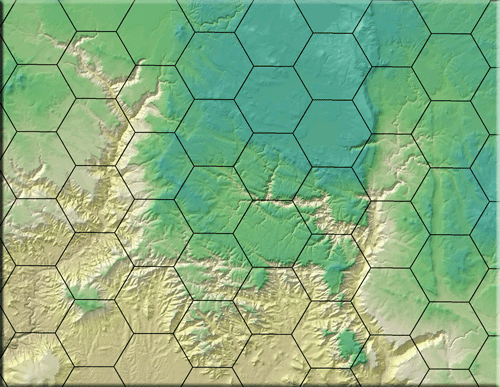
Shapes can be generated over all selected records of a feature theme, over the entire rectangular extent of a theme, over the rectangular extent of all themes in the view, or over the rectangular extent of the display.
For those who have access to ArcView 3.x, this extension can be used in conjunction with the
“Random Point Generator” extension (http://www.jennessent.com/arcview/random_points.htm)
to generate random points within a systematically divided sampling area.
This extension can be used to generate systematic polygons over the
landscape, and the “Random Point Generator” extension can then be used
to generate random sample points within those polygons.
Output: This extension produces either a point or a polygon
feature class and adds it as a theme to the view.
Updates:
| Version 1: August 13, 2006, Initial Release | |||||||||
Version 1.5.107: July 26, 2009:
| |||||||||
Version 1.5.110: October 30, 2009:
| |||||||||
Version 1.5.123: October 24, 2010
| |||||||||
Version 1.5.131: November 6, 2010
| |||||||||
Version 1.5.131: March 14, 2011
| |||||||||
| |||||||||
| |||||||||
| |||||||||
| |||||||||
|
Recommended Citation Format: For those who wish to cite this extension, the author recommends something similar to:
Jenness, J. 2012. Repeating shapes for ArcGIS. Jenness Enterprises. Available at: http://www.jennessent.com/arcgis/repeat_shapes.htm.
Current Citation List (from Google Scholar):
| Repeating Shapes |
Requires: ArcView 9.x or ArcView 10.x (will work at all license levels [Basic, Standard, Advanced; ArcView, ArcEditor, ArcInfo]).
Acknowledgments: Jenness Enterprises gratefully acknowledges the Ontario Ministry of Agriculture, Food and Rural Affairs for supporting portions of this extension.
![]()
For detailed installation and operations instructions, view the on-line PDF version of
Repeating Shapes
Manual
![]()
![]()
Enjoy! Please contact the author if you have problems or find bugs.
Jeff Jenness jeffj@jennessent.com
Jenness Enterprises http://www.jennessent.com
3020 N. Schevene Blvd.
Flagstaff, AZ 86004
USA
![]()
Please visit Jenness Enterprises ArcGIS Tools site for more ArcGIS tools and other software by the author. We also offer GIS consultation services for both ArcGIS and ArcView 3.x to help you meet your specific data analysis and application development needs.
![]()