
|
|
|
|
|
|
|
|
|
|
|
|
![]()
![]()
Polar Plots for ArcGIS
|
Last Modified June 23, 2014: Revision 1.0.253 |
|
|
Downloads |
On-Line Manuals (requires Adobe Acrobat Reader) |
|
Polar
Plots for ArcGIS 9.x (18.6 MB) Polar Plots for ArcGIS 10.0 (18.7 MB) |
Manual in Letter (8.5 x 11) page size |
Topics: Polar plot, Rose plot, Circular Statistics, Angular Deviation, Angular Variance, Mean Resultant Length, Circular Standard Deviation, Circular Variance
Author: Jeff Jenness
Wildlife Biologist, GIS Analyst
Jenness Enterprises
3020 N. Schevene Blvd.
Flagstaff, AZ, 86004 USA
(928) 607-4638
Description: This extension includes two tools. Both tools are available at the ArcView (aka ArcGIS Basic) license level.
| The Shapes to Segments tool converts polygon or polyline features into polyline features of individual vertex-to-vertex segments, with options on various geometric attributes to calculate (starting and ending coordinates, length, azimuth). | |
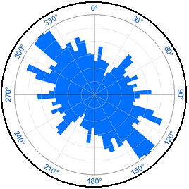
| The Polar Plots tool creates a graphic in the MXD layout illustrating the distribution of direction values in a feature class (such as those generated in the Shapes to Segments tool) or table. | |
| The Polar Plots tool also has an option to calculate basic circular descriptive statistics on data. |
Output:
| Layout Graphic of a circular plot. | |
| Circular descriptive statistics. | |
| A polyline feature class of vertex-to-vertex segments from an original polyline or polygon feature class. |
Updates:
Version 1.0.225: July 6, 2012
| |||||||||
Version 1.0.237: September 12, 2012
| |||||||||
Version 1.0.250: September 20, 2013
| |||||||||
Version 1.0.253 (June 23, 2014):
|
Recommended Citation Format: For those who wish to cite this extension, the author recommends something similar to:
Jenness, J. 2014. Polar plots for ArcGIS. Jenness Enterprises. Available at: http://www.jennessent.com/arcgis/polar_plots.htm.
Please let me know if you cite this extension in a publication. I will update the citation list to include any publications that I am told about.
Requires: ArcView 9.x or ArcView 10 (will also work at ArcEditor and ArcInfo license levels).
![]()
For detailed installation and operations instructions,
view the on-line PDF version of the
Manual.
![]()
![]()
Enjoy! Please contact the author if you have problems or find bugs.
Jeff Jenness jeffj@jennessent.com
Jenness Enterprises http://www.jennessent.com
3020 N. Schevene Blvd.
Flagstaff, AZ 86004
USA
![]()
Please visit Jenness Enterprises ArcGIS Tools site for more ArcGIS tools and other software by the author. We also offer GIS consultation services for both ArcGIS and ArcView 3.x to help you meet your specific data analysis and application development needs.
![]()