
|
|
|
|
|
|
|
|
|
|
|
|
![]()
![]()
|
*** Award Winning Software *** |
|
Last Modified: Revision 1.2.884, July 9, 2013 |
|
|
|
|
|
Downloads |
On-Line Manuals (requires Adobe Acrobat Reader) |
| Land Facet Corridor Designer for ArcGIS 9.x (18.6 MB) | Manual in Letter (8.5 x 11) page size |
|
View and Download Land Facet Corridor Designer Poster View and Download Full Corridor Designer Poster, Portrait View and Download Full Corridor Designer Poster, Landscape View and Download TPI Poster View Original TPI Poster by Andrew Weiss View and Download Mahalanobis Poster ---------------------------------- Featured in Fall 2010 Edition of ArcNews ---------------------------------- Download Land Facet Corridor Designer Raw Code Files (Visual Basic 6 project file, 42.8 MB) |
|
|
Note: This ArcGIS extension is part of a larger suite of tools designed to assist with corridor design and analysis. For additional tools, plus tutorials, literature, blogs and sample datasets, please visit the Corridor Designer website at http://www.corridordesign.org. |
|
Topics: Land Facet, Corridor, Topographic Position Index, Mahalanobis, Shannon Index, Density, Raster Inversion
Author: Jeff Jenness
Wildlife Biologist, GIS Analyst
Jenness Enterprises
3020 N. Schevene Blvd.
Flagstaff, AZ, 86004 USA
(928) 607-4638
Land Facet Corridor Designer is a geographic approach to designing wildlife linkages that will be useful in the face of impending climate change. This novel GIS-based procedure identifies the geographic portion of a region that maximizes continuity and diversity of landscape units defined by topographic and soil traits (such as high-elevation north-facing slopes with rocky soils, or low-elevation flats with thick soils) that are expected to facilitate wildlife movement. We refer to these topographic-soil units as land facets. The rationale is that future vegetation (and, indirectly, animal assemblages) and human land uses will be determined primarily by the interaction among land facets (soil and topography) and future climate regimes. The conceptual basis for this approach was recently published (Beier, P., and B. Brost. 2010. Use of land facets to plan for climate change: conserving the arenas, not the actors. Conservation Biology. DOI: 10.1111/j.1523-1739.2009.01422.x).
Land Facet Corridor Designer is explained in detail, and applied to three landscapes in Arizona, by Brost (2010, MS Thesis, School of Forestry, Northern Arizona University; available online). Publications from this thesis, with Brian Brost as senior author, should appear in the peer-reviewed literature in 2011.
Until now, practitioners designed corridors to promote movement of focal species through today’s land cover map. Because land cover maps are likely to change in this century, any corridor linkage based on those maps might fail during climate change. By conserving strands of land facets, linkage designs based on our new procedures should preserve the “arenas” that support current and future biodiversity, without relying on the modeled responses of the temporary occupants of those arenas.
Conservation practitioners now have a flexible tool to design and map corridors of land facets at high resolution (30-m or 10-m, depending on resolution of the DEM) that have a high probability of allowing for animal movement, including shifts of species’ geographic ranges, during and after climate change. This can enhance the ability to design wildland networks robust to climate change, reducing the impact of climate change on the biota of natural landscapes. These procedures are transparent and do not depend on global or regional circulation models.
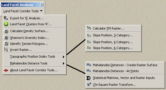
The Tools: This extension is intended as a companion to CorridorDesigner available at http://www.corridordesign.org, and we recommend that you also download and install those tools. The tools in this Land Facet extension will work fine without CorridorDesigner, but some of the general tasks (such as creating corridor polygons over a habitat suitability raster, or creating patch polygons) require functions from CorridorDesigner. The tools in Land Facet Corridor Designer provide an alternative way to create the “habitat suitability” raster (i.e. the cost surface), but using land facets rather than focal species. Once you have created that cost surface raster, then you can use the standard CorridorDesigner tools to create the corridor polygons.
This extension is also designed to work in conjunction with a set of Land Facet R tools, available near the bottom of the page at http://www.corridordesign.org/downloads. This ArcGIS extension does not use any R functions directly and therefore will work just fine without R installed. However, the Land Facet cluster function is entirely performed in R. This extension provides tools to export data in a format suitable for analysis in R, and it also includes tools to import the data that R generates. All other analyses and tools, including the Density Surface, Shannon's Diversity Index, Termini Polygons, Raster Inversion, TPI Tools, and Mahalanobis Distance Tools are performed entirely by ArcGIS and do not require R.
Recommended Citation Format: For those who wish to cite this extension, the author recommends something similar to:
Jenness, J., B. Brost and P. Beier. 2013. Land Facet Corridor Designer: Extension for ArcGIS. Jenness Enterprises. Available at: http://www.jennessent.com/arcgis/land_facets.htm
Current Citation List (from Google Scholar):
Requires: ArcGIS 9.1 or better (at any license level) or ArcGIS 10.
![]()
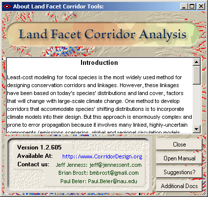
For detailed instructions on installation and
operation, view the on-line PDF version of
Land Facet Corridor Designer
Manual
![]()
![]()
Revisions
Version 1.2
Build 1.2.598 (March 31, 2010)
| |||||||
Build 1.2.797 (April 20, 2010)
| |||||||
Build 1.2.805 (April 27, 2010)
| |||||||
Build 1.2.808 (June 24, 2010)
| |||||||
Build 1.2.809 (July 1, 2010)
| |||||||
Build 1.2.813 (July 20, 2010)
| |||||||
Build 1.2.815 (November 6, 2010)
| |||||||
Build 1.2.816 (November 16, 2010)
| |||||||
Build 1.2.816 (December 29, 2010)
| |||||||
Version 1.2.831 (
| |||||||
Version 1.2.832 (April 28, 2011)
| |||||||
Version 1.2.840 (December 14, 2011)
| |||||||
Version 1.2.848 (June 13, 2012)
| |||||||
Version 1.2.874 (June 16, 2013)
| |||||||
Version 1.2.884 (July 9, 2013)
|
![]()
Enjoy! Please contact the author if you have problems or find bugs.
Jeff Jenness jeffj@jennessent.com
Jenness Enterprises http://www.jennessent.com
3020 N. Schevene Blvd.
Flagstaff, AZ 86004
USA
![]()
Please visit Jenness Enterprises ArcGIS Tools site for more ArcGIS tools and other software by the author. We also offer GIS consultation services for both ArcGIS and ArcView 3.x to help you meet your specific data analysis and application development needs.
![]()