
|
|
|
|
|
|
|
|
|
|
|
|
![]()
![]()
|
Last Modified: Revision 1.0.218, April 9, 2016 |
|
|
|
|
|
Downloads |
On-Line Manuals (requires Adobe Acrobat Reader) |
|
Conefor
Inputs Tool for ArcView 3.x (284 KB) Conefor Inputs Tool for ArcGIS 9.x (3.3 MB) Conefor Inputs Tool for ArcGIS 10.x (3.5 MB) |
Manual in Letter (8.5 x 11) page size |
| Note: This ArcGIS extension is a stand-alone tool that works independently of Conefor, but it is designed specifically to export data suitable for analysis in Conefor Sensinode 2.2. Please visit the Conefor website at http://www.conefor.org/ for more information. | |
|
Attention! Tom Dilts of the Great Basin
Ecology Lab has written a tool to bring Conefor outputs
back into ArcMap. To quote from Tom's text,
Visualizing outputs from Conefor in ArcMap involves several steps that can be tedious, and although ArcGIS extensions for importing GIS data into Conefor exist (Jenness 2011), no tools are available for exporting data to ArcMap. This tool fills that void by generating point shapefiles that show the centroids of patches, and line shapefiles that show varPC/dPC as well as the direct probability and maximum product probability of dispersal. From these shapefiles it is possible to make stick diagrams as an efficient way to display node and link importance in a habitat graph. See http://www.arcgis.com/home/item.html?id=62548c6b4c6e47119fcf1546ac26a603 For additional Great Basin Landscape Ecology Lab tools from Tom Dilts and Jian Yang, see http://www.cabnr.unr.edu/weisberg/downloads/ |
|
Author:
Jeff Jenness
Wildlife Biologist, GIS Analyst
Jenness Enterprises
3020 N. Schevene Blvd.
Flagstaff, AZ, 86004 USA
(928) 607-4638
This tool will calculate the distances between all features in one or more feature classes, optionally restricting the analysis to only features within a specified distance of each other. Output options include a dBASE table with the number of features within the specified distance, a dBASE table listing the pairwise distances between each pair of features, and/or an ASCII text file listing the distances between each pair of features.
These outputs may be useful for many types of analysis, but they have been specifically formatted to be used within the Conefor Sensinode Habitat Connectivity tools (see http://www.conefor.org/).
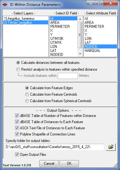
Requires: ArcGIS 9.1 or better (at any license level) or ArcGIS 10.x.
![]()
For detailed instructions on installation and
operation, view the on-line PDF version of
Conefor Inputs Manual.
![]()
![]()
Revisions
Version 1.0
Build 1.0.118 (July 24, 2008)
| |||||||
Build 1.0.123 (November 10, 2010)
| |||||||
Build 1.0.133 (December 3, 2010)
| |||||||
Build 1.0.146 (March 14, 2011)
| |||||||
Build 1.0.150 (June 9, 2011)
| |||||||
Build 1.0.162 (June 27, 2011)
| |||||||
Build 1.0.217 (November 18, 2012)
| |||||||
Build 1.0.218 (April 9, 2016)
|
![]()
Enjoy! Please contact the author if you have problems or find bugs.
Jeff Jenness jeffj@jennessent.com
Jenness Enterprises http://www.jennessent.com
3020 N. Schevene Blvd.
Flagstaff, AZ 86004
USA
![]()
Please visit Jenness Enterprises ArcGIS Tools site for more ArcGIS tools and other software by the author. We also offer GIS consultation services for both ArcGIS and ArcView 3.x to help you meet your specific data analysis and application development needs.
![]()