
![]()
![]()
![]()
![]()
![]()
![]()
![]()
![]()

NAME: Split Multipart Features (Click Name to Download)
Aka: split_multipart.avx
Last modified: March 1, 2005
TOPICS: Multipart Feature Complex Multipoint ShapeZ ShapeM Point Polygon Polyline
AUTHOR: Jeff Jenness, GIS Analyst
Jenness Enterprises
3020 N. Schevene Blvd.
Flagstaff, AZ 86004
jeffj@jennessent.com
DESCRIPTION: This is a straightforward extension which identifies and optionally separates all multipart features in a feature theme. Multipart features are those which are composed of separate, disconnected parts. A multipart polygon, for example, might be split into several polygon shapes. Selecting any one of these will select all of them because they are all the same object, and are all contained in a single record in the attribute table.
This extension has been tested on Multipoint, MultipointZ, MultipointM, Polygon, PolygonZ, PolygonM, Polyline, PolylineM, and PolylineZ features.
Output: In all cases, this extension will produce a report listing all multipart features it found in a theme. Optionally it can add a field to the theme attribute table containing the number of parts in each record. Optionally it can produce a new shapefile with all multipart features separated into separate features.
REQUIRES: This extension requires that the file "avdlog.dll" be present in the ArcView/BIN32 directory (or $AVBIN/avdlog.dll) and that the Dialog Designer extension be located in your ArcView/ext32 directory, which they usually are if you're running AV 3.1 or better. The Dialog Designer doesn't have to be loaded; it just has to be available. If you are running AV 3.0a, you can download the appropriate files for free from ESRI at:
http://support.esri.com/index.cfm?fa=downloads.patchesServicePacks.viewPatch&PID=25&MetaID=483
Recommended Citation Format: For those who wish to cite this extension, the author recommends something similar to:
Jenness, J. 2005. Split multipart features (split_multipart.avx) extension for ArcView 3.x. Jenness Enterprises. Available at: http://www.jennessent.com/arcview/split_multipart.htm
Please let me know if you cite this extension in a publication (jeffj@jennessent.com). I will update the citation list to include any publications that I am told about.
Updates: None Yet
![]()
1) Begin by placing the "split_multipart.avx" file into the ArcView extensions directory (../../Av_gis30/Arcview/ext32/).
2)
After starting ArcView, load the extension by clicking on File -->
Extensions… , scrolling down through the list of available extensions,
and then clicking on the checkbox next to the extension called "Split
Multipart Features."
3) This extension will add a single button
![]() to your View
button bar.
to your View
button bar.
4) Make sure your themes of interest are in your view.
5) Click the
![]() button to start the process. You will first be asked to identify your theme,
ID field, and output options. ID values are only used in the report and are
not a critical part of the analysis:
button to start the process. You will first be asked to identify your theme,
ID field, and output options. ID values are only used in the report and are
not a critical part of the analysis:
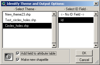
Add Field to Attribute Table: This option will add a new field to the selected theme containing the number of parts present in each feature.
Make New Shapefile: This option will produce a new shapefile identical to the original one, except that all multipart features will be separated into separate records.
The feature class of your new shapefile will be the same as the original feature class, with the exception of Multipoint shapefiles which will be converted to Point shapefiles.
All original fields and data in the attribute table will be transferred over to the new shapefile. All new shapefiles will get a field containing unique ID values. Additionally, new fields will added to your attribute table depending on the feature class:
| Point shapefiles will have X- and Y-coordinate fields added. | |
| Polyline shapefiles will have a Length field added. | |
| Polygon shapefiles will have an Area field added. |
These new fields will contain projected values if your view is projected.
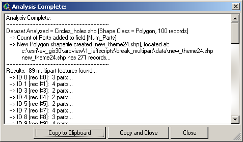
6) Click “OK” and the extension will go to work. Upon completion, it will produce a report describing exactly what it did:
![]()
Enjoy! Please contact the author if you have problems or find bugs.
Jeff Jenness jeffj@jennessent.com
Jenness Enterprises http://www.jennessent.com
3020 N. Schevene Blvd.
Flagstaff, AZ 86004
USA Please visit Jenness Enterprises
ArcView
Extensions site for more ArcView Extensions and other software by the
author. We also offer customized ArcView-based
GIS
consultation services to help you meet your specific data analysis and
application development needs.
![]()
![]()