Mexican Spotted Owl, stretching...

ArcGIS Tools
ArcView 3.x Extensions
GIS Consultation
Unit Converter
Jenness Enterprises
Search


Radiating Lines

NAME:  Radiating Lines and Points v. 1.1   (Click Name to Download)

Aka:  rad_lines.avx

Last modified:  March 7, 2006

TOPICS:  ArcView 3.x, radiating, radiate, origin, center, sample, sampling, point, compass, bearing, azimuth, View, Analysis, Tools

AUTHOR:  Jeff Jenness

Wildlife Biologist, GIS Analysis and Application Design

Jenness Enterprises

3020 N. Schevene Blvd.

Flagstaff, AZ 86004

jeffj@jennessent.com

DESCRIPTION:  This extension generates either or both of two separate shapefiles:  1) A polyline shapefile of a set of lines radiating outward from each of a set if Input points, and 2) A point shapefile of the endpoints of those lines.  This is a useful function for those who need to know the locations of a series of regularly-spaced points surrounding input points, or for those who need radiating lines extending outward at regular intervals from an origin point.  This is an especially useful function for determining sampling points around a point of interest.

This extension was developed for Jan Ekebom, Pasi Laihonen and Tapio Suominen of the University of Turku, for use on a study of Finnish Coastal Biodiversity.

All or only selected records: You can either use all the points in the point theme for the analysis or only a selected subset of points. If any points in your theme are selected, then only those selected points in that theme will be used in the analysis. If no points in your theme are selected, then all points in that theme will be used in the analysis.

Results:  Upon completion, you will have one or both of the following depending on your choice:

  1. A Polyline Shapefile containing the radiating lines extending outward from each point.  The Feature Attribute Table for these lines will contain 3 separate ID values, the length, the bearing, and the X- and Y- coordinates for both the origin and the end point. 
  2. A Point Shapefile containing the origin points and the end points of the radiating lines.  The Feature Attribute Table for these points will contain 3 separate ID values, a field delineating whether that point is an "origin" point or "end" point, the distance and bearing from the origin, and the X- and Y-coordinates of that point. 

REQUIRES: This extension requires a Point theme with Point ID values to be present in the view.

This extension also requires that the file "avdlog.dll" be present in the ArcView/BIN32 directory (or $AVBIN/avdlog.dll) and that the Dialog Designer extension be located in your ArcView/ext32 directory, which they usually are if you're running AV 3.1 or better.  The Dialog Designer doesn't have to be loaded; it just has to be available.

Revisions:

Version 1.1 (March 7, 2006) adds options to randomize the first bearing, and extends the function to input both PointZ and PointM shapefiles.

Recommended Citation Format:  For those who wish to cite this extension, the author recommends something similar to:

Jenness, J. 2006.  Radiating Lines and Points (rad_lines.avx) Extension for ArcView 3.x, v. 1.1.  Jenness Enterprises.  Available at: http://www.jennessent.com/arcview/radiating_lines.htm.

Please let me know if you cite this extension in a publication (jeffj@jennessent.com). I will update the citation list to include any publications that I am told about.

This software has been cited by:

Ekebom, J., P. Laihonen, and T. Suominen.  2003.  A GIS-based step-wise procedure for assessing physical exposure in fragmented archipelagos.  Estuarine, Coastal and Shelf Science.  Elsevier Ltd.  57:887-898.

General Instructions:

1)  Begin by placing the "rad_lines.avx" file into the ArcView extensions directory (../../Av_gis30/Arcview/ext32/).

2)  After starting ArcView, load the extension by clicking on File --> Extensions… , scrolling down through the list of available extensions, and then clicking on the checkbox next to the extension called "Radiating Lines." 

3)  Decide which point theme contains the points you’re interested in, and if you want to run this extension on all those points or just a subset of them.  If you want to generate radiating lines for a subset of the points, then start by selecting those points you’re interested in.  If any points are selected, then this extension will operate on only those selected points.

4)  From your View toolbar, click on the icon. This brings up the Input Theme dialog box:

     The Point Theme list contains all the Point themes from your view.  When you select the one you want, then the ID Field list will fill up with all the non-shape fields from that point theme.  Select the field that contains the ID values of each point.

     Next, enter the number of radiating lines or the bearing interval you want.  You only need to enter one of these values; as you enter data in one box, the other box will fill with the appropriate conversion.  In the above example, 13 radiating lines distributed evenly around the point means a bearing interval of 27.6923 degrees.

     Next, enter the line length in map units.  These are the units of your actual data, so if your view is projected then you might want to project your points before running this extension.

     You can set the first bearing to go in a random direction by checking the “Randomize First Bearing” checkbox. Otherwise the first bearing will point due North (0 degrees). The rest of the lines will be generated in regular angular intervals proceeding clockwise around the compass.

     Finally, select the output you want.  You can generate either a Polyline shapefile of the radiating lines or a Point shapefile of the endpoints, or both.  The feature attribute tables for these shapefiles include the following fields:

Polyline Feature Attribute Table:

bullet
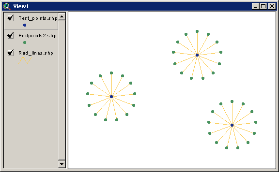
origin_id:  The ID value of the Origin point, taken from the input Point theme ID Field.  All radiating lines extending outward from a particular origin point will have that origin point's ID value in this field.
bulletorigin_#:  A unique numeric value reflecting the number of the radiating line with respect to that origin point.  If each origin point has 7 radiating lines, then the values in this field will range from 1 to 7 for each radiating line.
bulletunique_id:  A unique numeric ID value for each radiating line in this shapefile.
bulletdistance:  The length of this particular radiating line.
bulletbearing:  The compass bearing or azimuth if this particular radiating line, beginning at the origin point.
bulletorg_x_crd:  The X-coordinate of the origin point for this line.
bulletorg_y_crd:  The Y-coordinate of the origin point for this line.
bulletend_x_crd:  The X-coordinate of the end point for this line.
bulletend_y_crd:  The Y-coordinate of the end point for this line.

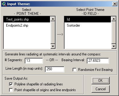
Point Feature Attribute Table:

bulletorigin_id:  The ID value of the Origin point, taken from the input Point theme ID Field.  All points surrounding a particular origin point will have that origin point's ID value in this field.
bulletorigin_#:  A unique numeric value reflecting the number of the point with respect to that origin point.  If each origin point has 7 radiating lines, then the values in this field will range from 1 to 7 for each origin point.
bulletunique_id:  A unique numeric ID value for each point in this shapefile.
bulletlocation:  This value will be either "Origin" or "End Point", depending on whether it is the origin point or one of the surrounding points.
bulletdistance:  The distance from the origin point to this particular end point.  If this point is the origin point, this value will be equal to "-999.000000."
bulletbearing:  The compass bearing or azimuth from the origin point to this particular end point.  If this point is the origin point, this value will be equal to "-999.000000."
bulletx_coord:  The X-coordinate of this point.
bullety_coord:  The Y-coordinate of this point.

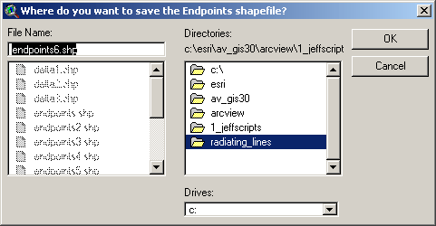
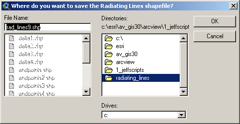
6)  Specify Hard Drive Locations to save your Shapefiles:  You will be prompted to specify a location on the hard drive to save your desired shapefiles. These are standard ArcView Dialog Boxes and should be familiar to most users. These files are permanent and will not be deleted when ArcView is shut down.

Enjoy! Please contact the author if you have problems or find bugs.

            Jeff Jenness                                      jeffj@jennessent.com

            3020 N. Schevene Blvd.

            Flagstaff, AZ  86004

                        USA

Please visit Jenness Enterprises ArcView Extensions site for more ArcView Extensions and other software by the author.  We also offer customized ArcView-based GIS consultation services to help you meet your specific data analysis and application development needs.